


-
Overview of Hwange National Park (HNP)
Hwange National Park (formerly called Wankie) is the largest game reserve in Zimbabwe. The park lies in the northwestern part of the country (19°00'S, 26°30'E, see map), on the main road between Bulawayo and Victoria Falls, bordering Botswana (see map below). It was founded around 1928 by Ted Davidson.
Hwange National Park covers over 14 600 square kilometres. The vegetation is typical of southern African dystrophic (low-nutrient soil) wooded savannah, with patches of grassland. The altitude ranges from 900 to 1 100 m. The climate is semiarid (long-term mean annual rainfall ~ 606 mm) and the rainy season occurs from the end of October to the end of April.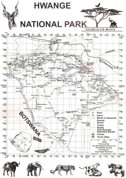
During the dry season, natural water is scarce, and surface water available to animals is mainly found in artificial waterholes, which have been developed since the 1930s by pumping ground water.
The park hosts 105 mammal species (including 19 large herbivores and 8 large carnivores) and about 400 species of birds. Since culling has been stopped 20 years ago, elephants have been very successful in Hwange. Their population has now reached 35 000 to 40 000 individuals!
Our main working site is the Main Camp area, located in the northwestern part of the park (red circle on the map). Accross this blog, you'll come over names such as Nyam (for Nyamadhlovu), Makwa, Guvalala, or Kennedy. All those names usually refere to waterholes. Here are a few pictures of them, so you won't get lost in the way...
 Tags: park, hwange, national, water, main
-
Comments
Across Southern Africa